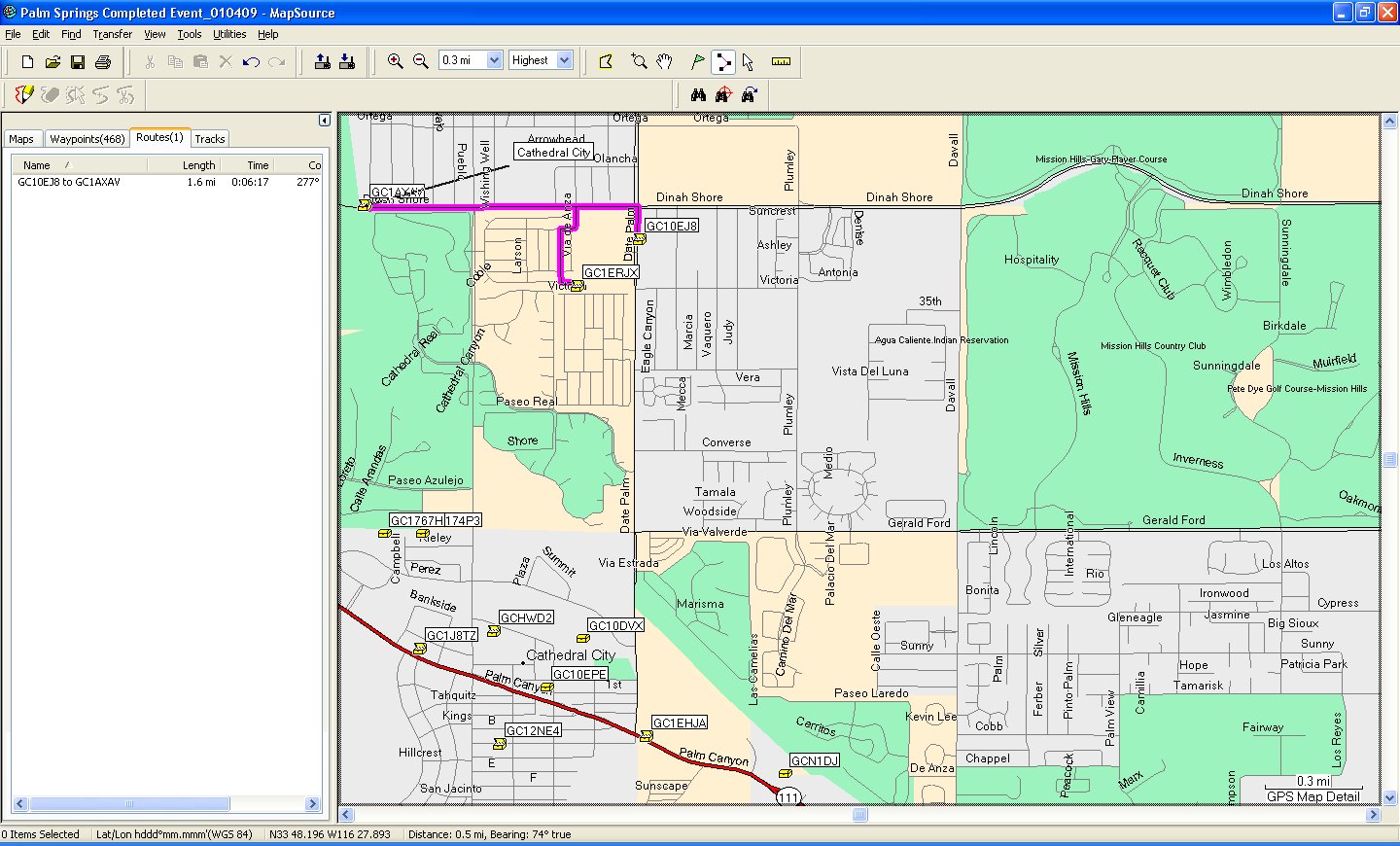
Now I did provide it on regular paper and it was nicely carved up into “phases” for the day, but you get the idea. If anyone got lost they could catch up real quick. How 6 people with multiple GPSr units PER PERSON could possibly get lost is beyond me, and beside the point (but it is why we left Calipers at home).
Want to create something like this for your next hunt? All that, and more, below the fold.
Pause for a momentary Reality Check
Before I get into the nitty gritty here I need to tell you there are a zillion ways of accomplishing this task and a few key limitations for almost all GPSr hardware that will prevent you from putting together “the perfect route”. This is not always the fault of the fine folks who manufacture GPSr hardware and software. These poor people have this sticky thing called “math” to contend with; more specifically, the Traveling Salesman Problem. So no matter how good your software, you will ALWAYS need to check longer routes by hand/eye and some well placed modifications for parking, facilities and etc. When that route seems to take you into the lower east backside of BFE just take solace in the fact that you can keep driving if you want. And just keep in mind there are hard limits on how big a route can be, sometimes as few as 50 Waypoints or turns. Your mileage will vary by make and model of GPSr.
All I’m interested in is the simple and straightforward approach. That’s why I…
Use the Software That Came With My GPS to Create a Route
In this example I will be showing you an approach using Garmin’s Mapsource. Magellan’s Mapsend (and just about everyone else’s) can do this too. But since you just use your GPS for Geocaching and never use the manufacturer’s software you have no clue what to do with it. For the already educated, all you are doing is using each Geocache Waypoint as a Route Waypoint, selecting each in the order you want to tackle them. Simple. For the rest of us, see down further below for details.
The Software That Came With Your GPS is Actually Pretty Good
Really, it is. It’s just not “built for Geocaching” like GSAK, Watcher, or fifty others. What it can do, flawlessly, is:
- Print maps
- Build routes
- Upload and Download to your GPSr
- Show terrain AND street level maps if you own them (unlike most other tools)
The third party software tools are purpose built for Geocaching so they are going to be good at what they do. Duh, right? The manufacturer’s software tools are built for MAPPING. They tend to be good at mapping, particularly the kind you do when creating routes.
You Really Need the Maps To Create Routes
Before you spend $450 on a state of the art Garmin and forget to pop a few bucks for the detailed maps just consider this: GPS is one of the most amazing technologies in the last 50 years. Why cripple the gear by failing to have detailed street and/or terrain maps loaded? Spend the $100-$125 for some maps. Please.
Step 1 – Open a GPX File With Your Software
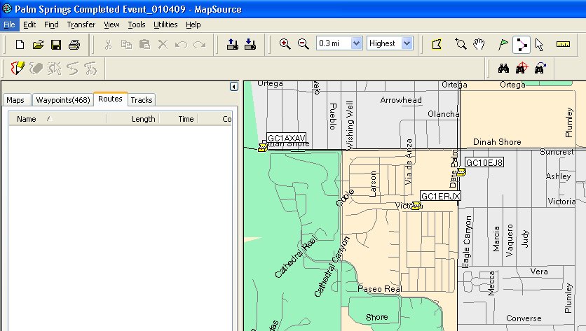
In the following picture, all I have done is open the GPX file I am using for this route. I’ve carefully weeded it out using my favorite technique. My software, Garmin’s Mapsource (City Navigator) has street level maps for this area already loaded up. I want to start with GC10EJ8 and then go to GC1ERJX, finally on to GC1AXAV. That looks to me like a reasonable approach.
Step 2 – Select the “Route” Tool and Go!
Again, this example is using Garmin Mapsource. Similar functions are widely available with other software tools.
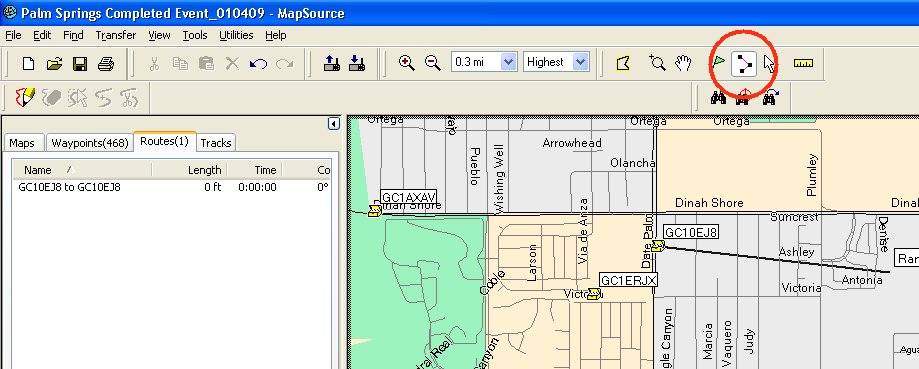
Here I have selected the route tool (circled) and clicked on the first Geocache waypoint, GC10EJ8. That will be my starting point. The line attached to GC10EJ8 is just pointing it out to you, since now that I have a first waypoint in my route the mouse cursor will be attached to the route by that little tether until I get done building it.
Step 3 – Click on the Rest of Your Geocaches (Waypoints) in Order
Simple, really.
You will want to look at the full size version of the screen shot so you can appreciate the full context. Notice on the left I have a summary of the distance and time for this route, while the roads to travel are now highlighted in the mapping window. As you add more waypoints the map will begin to show more directional symbols. In a simple 3-point route such artifacts are unnecessary.
Your Homework
Go run a few pocket queries and play around with the routing for a bit. Once you’ve experienced the full range of frustrations with routing, come on back. Maybe I’ll even dust off the Magellan software just for kicks and show you how I used to do it, old school…


Interesting Read! Very detailed blog.
Thanks for sharing
I aim to please! Comment with any questions or requests; I can usually figure out the stickiest of “how to” challenges.